


Best GPS Apps For Hiking
As recently as the turn of this century, every gas station and convenience store in the country had racks full of road maps. Nowadays, not only is it hard to find a paper road map, but many people won’t even consider taking a trip without their phone’s GPS app.
But if you’re camping, a driving app like Waze isn’t going to get the job done. You need an app that’s designed to guide you through all the parts of the map that aren’t on the road. To help you out, we’ve put together some of the best GPS apps for hiking.
Let’s begin!
AllTrails
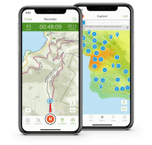 AllTrails is one of the best GPS apps for hiking, and it’s easy to see why. This is a comprehensive, full-featured app with a lot of extras, including social media features like photo geotagging, sharing your route with friends, and an active community of users who leave ratings on trails.
This app includes maps of 50,000 state, province, and national parks throughout the US and Canada. Each trail map includes a description, a list of permitted activities such as cycling or dog walking, the length of the trail, and the change in elevation throughout the trail’s run.
There are two tiers of service. The basic, free version of the app allows you to save your favorite trails and share pictures with your friends and family. However, if you’re doing serious backcountry hiking outside of cell phone range, you’ll need to upgrade to the paid version, since the free version doesn’t allow you to download maps for offline use.
Pros:
- Easy-to-use, intuitive design
- Social media sharing
- Lets you create custom routes
- Large user community provides many reviews
Cons:
- Offline use requires a paid subscription
Ramblr
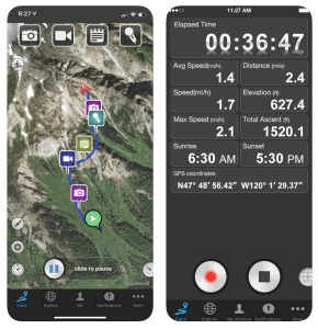 Rambler is a free hiking GPS app that offers more features than the free versions of other, paid GPS apps. What really stood out to us is that it allows you to download your maps and use them offline, which makes it the only good free option if your next excursion is going to take you out of your phone’s coverage area.
This app bills itself as a travel diary, and it comes with geotagging for both photos and videos. You can also update your social media status with your location and elevation. That said, any free product is going to have some downsides. In the case of Rambler, the user interface is unintuitive, so the learning curve is steep compared to other apps.
Pros:
- Functions as a multimedia travel diary
- Social media sharing
- Maps can be downloaded for offline use
- 100% free
Cons:
- Requires some sketchy permissions in order to run
- Unintuitive controls
Gaia GPS
 Gaia GPS has three subscription tiers. First is the basic, free version, which is a GPS topographical map that requires an online connection. With a paid membership, you gain the ability to download maps and use them offline or print them. But these features in and of themselves are nothing special.
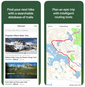
Where Gaia really shines is its premium membership features. At this tier, you get access to maps of all continents except Africa and South America. More impressively, you get overlays that show hunting zones, land ownership, ski trails, and access to the NatGeo Trails Illustrated map pack. With this one, it’s the subscription that makes it one of the best GPS apps for hiking.
If you’re looking for a free app, there are better options out there. But if you’re willing to pay for a large suite of features, Gaia offers more than any other app.
Pros:
- Detailed topographic maps
- European, Australian, and Asian maps available
- Land ownership and hunting zone overlays
- Multiple membership tiers
Cons:
- Most features require a paid subscription
Cairn
 Cairn is a paid app that comes with a 30-day free trial. After that, you’ll still have access to maps as long as you’re online, but not to any of the extra features. As with Gaia, there are better free apps out there.
So why would you pay for a Cairn membership?
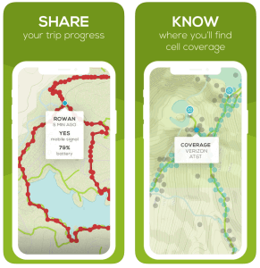
The answer is safety. This app allows you to pre-program your route and schedule, and to send text alerts to a contact of your choice when you’re starting or ending your hike. If you’re late getting back, it will automatically send a text to your emergency contact, telling them that you’re late.
Not only that, but Cairn’s maps have an overlay that shows cell coverage and tower locations. So if you’re out of range in an emergency, you can get back in range as quickly as possible.
Pros:
- Several safety features
- Includes a cell coverage map
- Ideal for solo hikers
Cons:
- Android version is still in beta
Conclusion
Well, there you have it. The best GPS apps for hiking. Now all you have to do is download, and you’re ready to get out on the trail. As the immortal Doc Brown said: “Roads? Where we’re going, we don’t need roads.”
You might also like: 10 Hiking Tips To Stay Safe In The Woods!


